AZC architects came up with this brilliant concept in response to ArchTriumph’s ‘Bridge in Paris’ competition, the project invites visitors to engage in a more playful navigation through the City of Romance.
Thursday, October 18, 2012
Monday, September 17, 2012
The Liffey Quays, A Ribbon of Green
Last Saturday, September 8 I was asked to be one of the speakers
at TEDx Dublin at the Grand Canal Theatre. I spoke about my practice as an
artist and how it has focused on the subject of the Liffey.
In 2011 I installed a floating desert island on the river
and lived there for a week. While sitting there, taking in the whole city from
a very unique vantage point a very clear idea came to me.
I imagined a ribbon of green unfurling along the Liffey Quays, a 4km linear park extending the whole way between Heuston Station and Dublin port on both the North and South Quays.
The vast majority of the motorway along the quays has at least three lanes and in some stretches onstreet parking too.
This linear park would be created by removing this onstreet
parking and shutting down the traffic lane closest to the river. Buses
would have to share the traffic lane furthest away from the river.
Two lanes of traffic would be maintained at both sides of the river. The resulting freed up space would become a walkway/linear park along the quaysides.
The only considerable stretch of the quays that is not wide enough to accomodate this park is a 400m section of the north quays between the James Joyce Bridge and the Four Courts. A new boardwalk could be constructed in this area.
The campshires of the docklands area already exist as a linear park between the IFSC and the O2. Traffic lanes would not need to be removed in this area.
An architectural competition could be launched to find a design for the park that links these campshires with the existing boardwalk and the newly widened walkways along the quays.
Image: Brendan Redmond
New granite walls with inbuilt vertical planting could separate the park/walkway from the traffic.
The whole park would need a uniform design in relation to seating, lighting, paving and planting. Something as simple as a continuous ribbon of narrow green tiles could curve and flow along the whole length of the park and across the bridges to create a sense of a unified space.
A trust could be set up to manage and maintain the park and
curate an ongoing series of projects including art installations, markets, gigs
and walking tours.
Amenities to include sandpits, playgrounds, skateparks, a
visitors centre, a floating swimming pool and a kayaking centre could be sited
intermittantly along the park.
Image: Antoin Doyle
Image: Antoin Doyle
Image: Anna Monaghan
A visible team of gardeners, guides, volunteers and security could act as the face of the park and spread the message positively that anti social behaviour is not tolerated and that the Liffey quays have become a secure environment that everybody can enjoy. Without a doubt it would be challenging to enforce this shift but overtime surely possible!
Image: John Keating

An ongoing marketing and PR campaign would spread the good news that the Liffey Quays have become a must see, World class destination. The park would become the first port of call for visitors to the city.
Ultimitely the park could grow offshoots along neighbouring
streets connecting the Liffey Quays with some of Dublin's most loved
tourist attractions including the Phoenix Park, IMMA, Collins Barracks, the
Guinness Storehouse, Christchurch Cathedral and Trinity College.
The Ribbon of Green would kickstart a renaissance that resonates right through the inner city. People from all types of socio-economic backgrounds would want to live along the Liffey and its' neighbourhoods. New buildings with family sized apartments could cater for this new demand. Shops and cafes would open along the quays catering for the thousands of people that would use the park on a daily basis.
Dublin exists because of the Liffey, the city grew around the river because of its transport connections and ready supply of water. The Liffey, Dublin's beating heart, its' central artery is the real centre of the city. It has become obsured and impossible to access due to the six lane motorway that funnels thousands of vehicles around it every day.
The Liffey needs a new frame, this park could become that. Let's make it happen!
Wednesday, August 15, 2012
Badboot

Source: Architecturetoday.co.uk
One of the world’s biggest, floating open air swimming pool named Badboot will open on the Eilandje in Antwerp (Antwerp Docklands) in mid-August 2012. The floating structure, with a total length of 120 metres, can accommodate 600 people and consists of a swim basin, two event venues, several floors and a restaurant with a lounge terrace.
Designed by architect Pieter Peerlings together with partner Silvia Mertens of Sculp(IT) Architects , the project has been conceived jointly by Philip De Prest, managing director of V-Zit bvba, with the City of Antwerp.
Whilst outdoor, floating swimming pools are found in Berlin, Paris and Copenhagen, the Badboot differs from all other European precedents by being significantly larger with a 40 metre pool. The Badboot can also be moved around the city to other sites and will be open throughout the year. In winter, however, the pool will function as an ice rink and venue for other winter sporting activities such as curling.
John Rocque
Somebody posted an image of an old map of the Liffey on facebook today. I was sure it had been used on an old Irish bank note (pre euro) and did some searching online. It turns out that my memory is to be trusted, it was on the back of the ten pound note and the image is taken from the 1756 map of Dublin by John Rocque. What interests me about the image is the amount of ships and boats on the Liffey, hard to imagine now that it once was such a bustling transport hub 250 years ago.
Source: Wikipedia
Source: Wikipedia
John Rocque (1709–1762) was a surveyor and cartographer.Rocque is now mainly remembered for his map of London. He began work on this in 1737 and it was published in 24 printed sheets in 1747. It was by far the most detailed map of London published up to that time, and remains an important historical resource.
The map of London and his other maps brought him an appointment as cartographer to the Prince of Wales in 1751.
His 1756 map of Dublin featured on an Irish Ten Pond banknote. The Area around Dublin city is covered on 4 maps. They extended as far as Skerries and Cardy Rocks to the North, Carton House to the west, Blessington to the south west,and Enniskerry to the south.
Sunday, August 12, 2012
Barking Bathhouse
Source: www.createlondon.org
Axe Street, IG11 7LX, Barking & Dagenham
CREATE has commissioned Something & Son to design and build a unique new space, the Barking Bathhouse, that draws on innovative health, beauty and design practices to bring about a little bit of happiness and relaxation this summer.
Something & Son is the design practice behind the hugely successful FARM:shop in Dalston, in which a fully functioning farm has been created in a disused shop. Its approach for the Bathhouse is rooted in a long history of British inquisitiveness and experimentation, and reflects its passion for social enterprise, sustainability, engineering and art.
The Bathhouse revives the spirit of Barking’s former Bathhouse, which, before closing in 1986 after 87 years of operation, catered for the health of thousands of local people and even hosted events, dinners and dances until the 1960s. The 6,000-square-foot new structure is inspired by both 20th-century working men’s bathhouses and ultra-modern spas, and combines modern spa technologies with functional design that draws on Barking’s industrial heritage, the black-stained timber farm buildings of Essex and the wooden beach huts of Kent. Its raw aesthetic challenges traditional notions of luxury whilst creating a blissful space to relax, and its pod-based design, which was prefabricated and assembled on site, was planned with the future in mind, so that after it closes, the pods can be relocated individually or together for continued use by the local community.
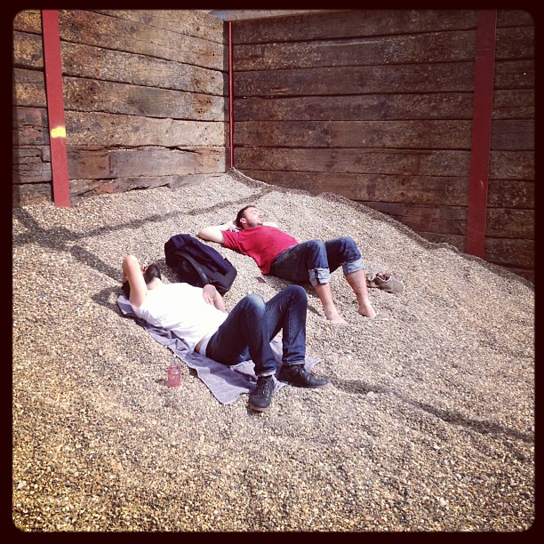
For the ultimate in indulgence, the Bathhouse combines a spa with a bar. A series of massage and treatment rooms lead to a traditional sauna and a cold room lined with ice blocks, bringing traditional bathhouse rituals into the experience. Massages, body treatments, manicures and pedicures are all offered, and Something & Son has worked with local beauticians and gardeners to develop natural treatments that use produce from local allotments. In the relaxation area, spa visitors will be able to socialise and sunbathe on loungers in seaside-inspired pebble bays under an open roof, whilst in the bar, they can sip healthy cocktails and smoothies under a canopy of cucumber vines that also provide the raw materials for treatments next door. Shingle dunes provide the perfect space to relax and unwind between treatments.
The Bathhouse also runs a varied events programme – from philosophical talks to chocolate-making workshops, plus laughter yoga, clowning workshops and comedy nights, its ethos is to cultivate happiness and wellbeing.
High Line Art
![]() |
| Tonoaki Suzuki |
David Shrigley
|
Sarah Sze
|
Source: www.highline.org
Presented by Friends of the High Line, High Line Art commissions and produces public art projects that take place on and around the High Line. Founded in 2009, High Line Art presents a wide array of artworks including site-specific commissions, exhibitions, performances, video programs and a series of billboard interventions. High Line Art invites artists to think of creative ways to engage with the uniqueness of the architecture and design of the High Line and to foster a productive dialogue with the surrounding neighborhood and urban landscape.
High Line Art is curated by Cecilia Alemani, the Donald R. Mullen, Jr. Curator and Director of High Line Art at Friends of the High Line.
Subscribe to:
Posts (Atom)